3 Ways Location Intelligence Is Already Part of Your Life

So what’s the best way to learn any new analytics technology? Tell a story. Stats are fun and features are great, but it’s all just talk without context. In this spirit, we’re going to show you some examples of how location intelligence can be an ideal platform for out-of-the-box thinking in real-world settings.
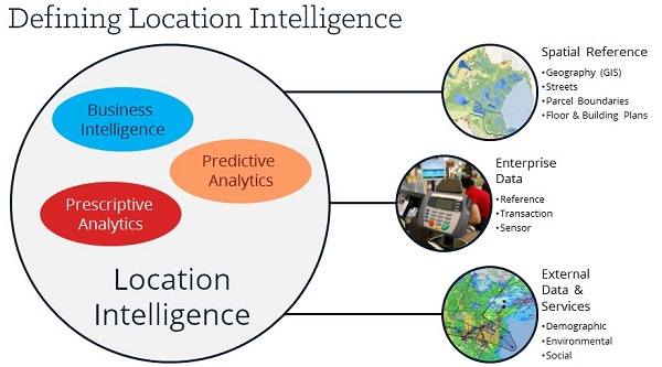
Just to set the stage, let’s start with a quick, easy description around what location intelligence is and what it does. At its heart, location intelligence is all about enabling you to see internal and external data relevant to your business visualized in the real world. Using these intuitive displays, you can see what’s impacting your current state, plot future trends, and define clear actions to move your organization forward.
There’s literally a world of possibilities (wink, wink) out there for location intelligence. Let’s take a look at three concrete ways it’s already at work around us every day.
1. Fueling Operational Efficiency at UPS

I know, I know, I’m starting an article about supposedly unique location intelligence applications with a logistics and delivery company. Super original, right? Well, even though the pairing between location intelligence and UPS might seem painfully obvious, what’s unexpected here is the magnitude of the impact it made on their business practices.
UPS started their journey into location intelligence with a simple question: how can we operate our vehicle assets as efficiently as possible while keeping our drivers as safe as possible? To find out, they used data from telematic sensors installed in 46 thousand of their vehicles to see in real time what conditions were like on the roads, receive diagnostics from each van, and automatically recommend the best courses of action to their drivers based on this information coupled with relevant variables for the area in which they were traveling. The drivers could see these recommendations in an easy-to-interpret, GPS-like display in the van, allowing them to take in the information at a glance and make quick adjustments.
The results were astounding. Through analyzing the location-based data they collected and visualizing it for their drivers, UPS saved 8.4 million gallons of gas and traveled 85 million fewer miles per year. These new efficiencies added up to $50 million in annual savings and a 35 percent increase in employee productivity. With all this extra cash freed up, UPS was able to double their drivers’ wages, ensuring employee retention and satisfaction.
2. Driving Membership and Viewership at Netflix

Ever wondered why your favorite shows are your favorites? As it turns out, location intelligence might have a hand in it, especially if you’re watching on Netflix. One of the reasons why Netflix’s original series have been so well received is the analytics they’ve put into creating them.
To better optimize show content for audience demographics and to drive membership and viewership, Netflix built out some in-depth cohort analyses to find the relationships between the viewing, rating, and searching behavior of their 25 million members, the geolocation, time, and viewing device information for each member, and the integration of the members’ show ratings with social media. These factors combined to give them a comprehensive picture of what kinds of shows were resonating with what regions, where the greatest densities of viewers were, and what days and times showed the most viewing activity in which areas.
Now armed with a comprehensive activity map of all their users, Netflix was able to start writing plot lines, designing sets, and casting actors all tailor-made to fit the preferences of their different viewer cohorts. They were also now capable of selecting release times based on proven benchmarks of high activity. Having this information led Netflix to create one of its most critically acclaimed series ever, raking in 3 million opening weekend views and receiving over a dozen awards. So just remember, next time you settle in for an epic Netflix marathon you’re probably watching something literally designed for you.
3. Predicting Law Enforcement Hot Spots at the Manchester NH Police Department

Have you ever thought about how the weather impacts the crime levels where you live? Turns out it’s an important factor along with a number of other environmental variables like geography and history. Location intelligence can help law enforcement officials to pinpoint where they’re needed most by analyzing and visualizing these complex relationships, and the Manchester NH Police Department has started using it to do just that.
Working with Ironside data scientists, Manchester PD implemented several spatially based predictive models that can deliver near real-time predictions of criminal activity during any work shift down to a 500 square foot street segment. These predictions then get pushed out to the GPS-enabled mobile data terminals (MDTs) in every one of Manchester PD’s cruisers, allowing officers to understand where they’re most needed before a call even comes in and empowering the department to know with certainty that their resources are allocated effectively and that their patrol routes cover the most likely activity hot spots.
As you look deeper into location intelligence, you’ll start seeing more and more possibilities. It can all get a little overwhelming, but we’re here to help. If you’d like to get the scoop on some more applications for this powerful new way of showing data as life around you, watch Ironside’s Location Intelligence Webinar OnDemand. We’ll help you put your data on the map.